今日から「Japan’s little-known seafaring past -「日本の知られざる海運の歴史」を読んでいます。
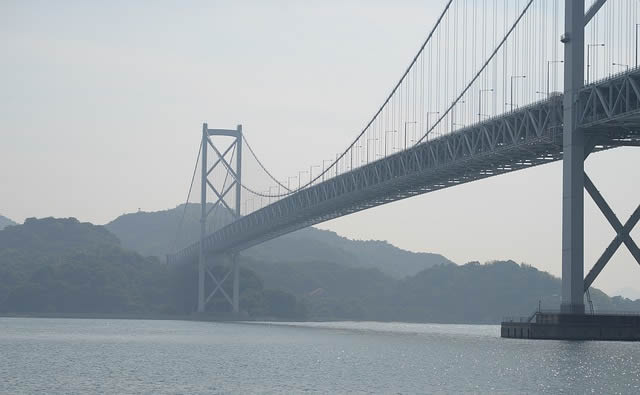
Speeding along at 65m above sea level with an exhilarating view of islands in all directions and cargo ships in the churning waters below, I felt like I was parasailing.
海抜65mで四方の島々や貨物船を眺めながら、まるでパラセーリングをしているような爽快な気分でスピードを上げていく。
In fact, I was driving on the world’s longest suspension structure, the Kurushima Kaikyo Bridge.
実は、私は世界最長の吊り橋である来島海峡大橋をドライブしていた。
More than 4km in length, the bridge is one of eight long-span bridges on the 60km Nishi-Seto Expressway, known as the Shimanami Kaido, which means Island Wave Sea Road.
全長4kmを超えるこの橋は、約60kmにわたる西瀬戸自動車道の8つの長大橋の一つで「しまなみ海道」と呼ばれている。
The only route through the Geiyo Archipelago – a group of mountainous islands clustered at the heart of Japan’s main waterway, the Seto Inland Sea
日本の主要な水路である瀬戸内海の中心に群生する山々、芸予諸島を通る唯一のルートで
- the expressway connects the islands to Onomichi City on Honshu Island in the north and Imabari City on Shikoku Island in the south.
北は本州の尾道市、南は四国の今治市まで高速道路で結ばれている。
Until the Shimanami Kaido was completed in 1999, the Geiyo Islands were a remote region, accessible only by boat.
1999年にしまなみ海道が完成するまで、芸予諸島は船でしか辿り着けない秘境だった。
Around the islands are the most treacherous straits in the country.
島の周りには、国内でも最も危険な海峡がある。
treacherous「裏切りをする、そむく、不忠・不実な、~を裏切って、あてにならない、油断できない、危険な」。
The Seto Inland Sea is where the Pacific Ocean flows through Japan;
瀬戸内海は、太平洋が日本列島を通って流れる場所で、
shifts in the tide create complicated underwater currents and fast whirlpools due to the islands’ topography.
潮の満ち引きで複雑な海流が発生し、島の地形によって速い渦巻きが発生する。
whirlpool「渦巻き」。
topography「地勢、地形、地形学」。
行ってみたいな~しまなみ街道~♪
関東で生まれ育ったので、四国は遠い遠い憧れの土地です。
岡山の倉敷までは行ったことがあるんですが、それより先はなかなか。
冒頭の文章にあるように、しまなみ街道をドライブすれば、海上を走るような気分なのでしょうね。
しまなみ街道のある芸予諸島の歴史、早速読んでいきましょう!
理由は単純明快!「少ないコストでしっかり楽しく学べるから」。
私自身の経験(高機能でビックリ)をびっしり書いていますので、良かったら読んでみてください。
下のバナーからどうぞ!

")